The commercial drone industry is rising like mushrooms after a rain, following recent moves by the Federal Aviation Administration that remove uncertainty about how it is likely to regulate drone flights once the laborious federal rule-making process runs its course. Pent-up demand has encouraged entrepreneurs who are starting up operations to follow the spirit, if not the letter, of the as-yet-to-be-finalized regulations.
One such start-up is WORKMODE, an initiative of SkyCatch, a San Francisco-based operation launched Feb. 23 that some already have dubbed "the Uber" of the drone business.
The company invites would-be commercial drone pilots to register on its website and pass a short qualifications exam, after which they are offered space for a profile to identify their specialties and credentials as well as match-making services with prospective customers.
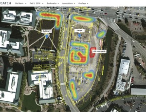
Once matches are made, the web-based service has map mark-up tools and agreement forms to define the scope of contracts for services. The pilots make their own deals with customers, but after the flight they can upload raw images to Workmode, which will process them and deliver map products, including 3D images, to clients.
"What we bring to the table in SkyCatch is the organization of the problem itself and opportunity to get business," says Ambar Pansari, director of SkyCatch products. He is the leader of SkyCatch's Workmode initiative.
Workmode is open to drone pilots who pass an online safety test and who fly aircraft capable of navigating via GPS waypoints to cover pre-mapped areas. The system can process data captured on the visible light spectrum in the RGB color mode as well as multispectral and thermal images as long as the sensor is mounted on a dampened or stabilized mount or gimbal.
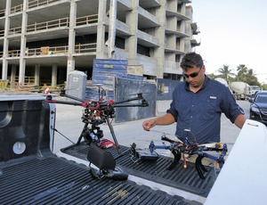
"When we started getting into the mapping, we tried some online processing services and we tried processing images ourselves," says Trevor Duke, co-owner of Fort Lauderdale, Fla.-based Icarus Aerials LLC. "[But} SkyCatch is the best processor of data that we have come across and has the most attractive output.
"It's very easy to use. We don't get a ton of referrals from them—but that's no fault of theirs ... the whole industry is very early," Duke says.
"We have had quite a bit of early success getting pilots into our system," says Pansari. The site already has signed pilots around the world, says Farah Wahab, special projects coordinator.
Duke, one of the first to sign up, "came out of the woodwork," says Pansari. "And now he has to get out there and sell the value of what he is providing."


Post a comment to this article
Report Abusive Comment