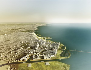
Computer scientists are teaming up with planners, developers and big data tools to inform decisions about megadevelopments. The goal of one fledgling effort is to develop a prototype computational framework that would be instrumental in planning the infrastructure for the future 600-acre Chicago Lakeside Development, a minicity sited on a former U.S. Steel complex on Lake Michigan, 10 miles south of downtown.
"Planners don't want to rely on intuition or hope. They want to rely on science," said Charlie Catlett, co-director of the $400,000 LakeSim computational project, at the Architectural Record Innovation Conference 2013, held on Oct. 3 in New York City. AR and ENR are published by McGraw Hill Construction.
The aim of the six-month project, which kicked off last month, is to develop simulation software that knits together multiple infrastructure planning applications. The tool will let Lakeside's planner, Skidmore, Owings & Merrill, explore many scenarios. SOM could investigate, for example, how increasing park land might affect stormwater management.
The project—funded by Chicago Lakeside developer McCaffery Interests Inc., the U.S. Dept. of Energy's Argonne National Laboratory and the University of Chicago—initially will link data relating to stormwater runoff as well as energy, water and transportation demand for all 700 buildings in the plan.
Using the software, SOM will be able to change system parameters and get answers to McCaffery's questions in hours, instead of days or weeks, says Catlett.


Post a comment to this article
Report Abusive Comment