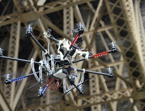
Researchers have developed an unmanned aerial vehicle that can fly itself. Taking 3D scans of its surroundings, the drone can process that data fast enough to navigate in real time, without hitting objects. The scans are accurate enough to use for other purposes, too, such as infrastructure inspection.
Typically, inspectors visit a site every 12 to 18 months and generate handwritten notes that vary in detail and accuracy according to the inspector, says Daniel Huber, senior systems scientist at Carnegie Mellon University's Robotics Institute, Pittsburgh. "They might take some photos but don't make a comprehensive representation of the structure," he says. As a result, assessment of the structure over a long period of time can be quite difficult, Huber adds.
Large-scale projects, such as the Golden Gate Bridge, introduce an element of danger. Inspectors are often required to climb cables or use helicopters. "Solving this problem isn't a new idea," says Huber. What is novel is the concept of investigations that are more effective than current methods, such as surveying or using a terrestrial laser scanner. His team's solution is to take scanning to the sky. Using laser scanners, the Aerial Robotic Infrastructure Analyst (ARIA) collects 40,000 x-y-z points per second to build a point cloud of its surroundings.
Researchers draw a spatial "bounding box" around a structure, and ARIA navigates in, out, over and around the structure while staying within the box's parameters, says Luke Yoder, an institute robotics researcher.
The novelty is that ARIA can put a 3D laser scanner anywhere, Yoder says. Automated drones on the market often are used for photogrammetry, according to Yoder, but these vehicles use a GPS system to navigate and assume there are no obstacles in the way. "They fly a raster pattern as they go," he says. By quickly scanning its surroundings as it flies, ARIA can reach areas of a structure that are out of GPS range and dangerous for humans and it can come back with a 3D scan of structural breakdown. "This system gives you a complete point cloud without holes—and quickly," Yoder points out.


Post a comment to this article
Report Abusive Comment