Bentley Systems' latest addition to its suite of infrastructure design software helps utilities gather everything they know about existing systems and assigns reliability values as a foundation for future planning.
The product—referred to as SUE, for subsurface utilities engineering—uses BIM-style tools to create intelligent 3D models of combined subsurface utility systems, which it does by automating the use of legacy design data and mashing it up with new design inputs.
Jack Cook, Bentley's vice president for product management, and Rachel Rogers, marketing director for civil, geospatial, hydraulics and hydrology software, say SUE is a toolset built on Bentley's InRoads and OpenRoads technology. SUE's model builder creates intelligent, 3D, feature-based models using a customizable, parametric library of buried-utilities objects. SUE, part of Bentley's annual update on products it announced in April, is available—for $2,995—with the newest "refresh" releases of Bentley's Civil Design software offerings.
Cook says SUE can "extract, transform and load" legacy asset data from many sources, including survey information, CAD, GIS, Excel spreadsheets, Oracle databases and other industry- standard sources. It can then automatically build 3D utility models from the data and synchronize the combined, corrected and rationalized data back into geospatial asset databases in a two-way exchange.
"That's the biggest point, the takeaway," says Rogers. "SUE lets you automatically create 3D models from your data."
The system builds the model within a digital terrain of the site, automatically burying features according to the documented cover, or trenching for proposed new work as defined. New work can be tested for hard and soft clashes in real time and designs parametrically adjusted for corrections.
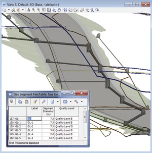
SUE offers side-by-side 2D and 3D views and has filters for grouping features and assigning attributes, as well as context-sensitive, pop-up, attribute editing tools that open when an object is hovered over. The geometric reliability of the data can be assigned a confidence level, according to a standard scale.
"The most common starting point is a line on a map; just a representation that has gone thorough a chain of customers," says Cook. "That's a quality level 'D.'"
"Quality level 'A' is something you have eyes on," Cook continues. "It could mean you brought in a vacuum excavator to expose a tangle of communications lines so you can actually see it. 'B' would be something detected by ground- penetrating radar or other sensing methods, and 'C' would be [inferences derived from] artifacts visible on the ground, like streetlight pedestals or valve covers.
"It's all about the risk, and making the risk flow transparent to operations and construction, so whoever is going into the ground can plan to manage it—or deal with the potential impact of ignoring it,"says Cook, adding, "We have always been deficient in the as-built. It's a big source of leakage of value and information. But if you capture it as quality level 'A' and send it back, it is quite possible you could maintain it as quality level 'A' [from then on]."


Post a comment to this article
Report Abusive Comment