A new browser-based, stand-alone software released in late June searches local, system and removable drives to discover and index the geospatial data of more than 100 formats. It creates a graphical geospatial data catalogue from vector and image files.
"When I started in this industry, you were lucky to fit two satellite images on your hard drive," says David Stanley, chief technology officer at PCI Geomatics, the Ontario, Canada-based photogrammetric software development company that released Geomatica Discover. "Now, people pass around four-terabyte hard drives."
The expanded capacity causes problems, however, when searching through hundreds or thousands of satellite images and their connected files to find one specific image or file. Geomatica Discover was made to solve the problem.
The software crawls through external and networked hard drives and discovers existing geospatial data holdings. Once the files are discovered, the software creates a data footprint, which can be queried by image type, resolution, sensor type, acquisition date or geolocation. Images can be sorted based on metadata or defined rules to organize them into sets for bundling or sharing.
"Most of the images have never had useful names. So you have a file named AB-73984—that tells you nothing," says Stanley. "Geomatica Discover is like Microsoft Word's 'control + F' [find] function, only for geographic images and metadata."
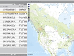
The software also allows for visual searching. In the visual search mode, data is pinned to its geographic location on a world map. Only the image files are displayed, leaving out the many related, non-image processing and .xml files.
Stanley says he knows of no other stand-alone software to search and index satellite imaging and vector files. There are enterprise-level solutions. "It's $2,500 a seat for perpetual use," Stanley notes.


Post a comment to this article
Report Abusive Comment