A group of MIT researchers recently completed a series of test flights, navigating an airplane that operates without human control or an onboard GPS navigation system through a close-quarters course in a parking garage.
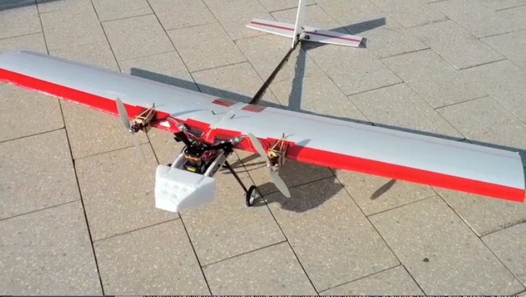
The plane looks like a model airplane, but it has advanced technology in its guts that can be seen sticking out behind the nose. The two-meter wingspan is just shy of some spaces in the parking garage where it was tested. The tracking technology developed in the project is available to the public. One possible re-use of the technology is to track construction workers in dangerous situations where GPS is not available.
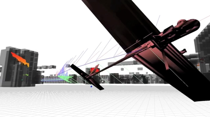
"The vehicle is localizing against a 3D map," says Abraham Bachrach, an electrical engineering grad student at MIT. "It fuses information from inertial sensors and a 2D LiDAR carried onboard to estimate its state. All computation is done onboard the vehicle, but it sends its position back to the base station over WiFi so that we can monitor it."
The technological advance demonstrated by the tests isn't as much the successful monitoring, however, as it is the autonomous-control algorithms that were developed at MIT over the past few years, says Adam Bry, a graduate student in MIT's department of aeronautics and astronautics. "The plane's laser can see 30 meters, and it is flying 10 meters a second, so it has at most three seconds to maneuver," says Bry, who, together with Bachrach and Nicholas Roy, MIT associate professor of aeronautics, built the self-flying plane.
The team has yet to develop the algorithms to take off and land autonomously, so the plane must be launched by remote control before flipping a switch that allows the system to take over. Bachrach says Bry is a great pilot. The landing and takeoff are the most difficult maneuvers, Bry says.
At the 2011 International Conference on Robotics and Automation, the team debuted an algorithm that calculates a plane’s trajectory. At the 2012 conference, they debuted an algorithm that describes a plane’s state—its location, physical orientation, velocity and acceleration. The data, collected in real time, and a 3D map allow the plane to navigate on its own.
"Nothing about the algorithm is specific to an air vehicle," says Bachrach. "So, in practice, the algorithm could be used to localize a ground vehicle, person, animal, whatever." While Bry agrees the onboard technology could be used to track workers in a GPS-denied area, he says that could be done with a lot less precision than this technology offers.
Bry says, "The next step is to track the plane without a map of the area in which it's flying." The team did this when working with quadrotors. They were able to fly these without a pre-loaded 3D map, says Bachrach, "but it was limited to slower and more stable flight."


Post a comment to this article
Report Abusive Comment