


Augmented Reality is one of the hottest trends on smartphones, with applications such as Layar and Wikitude providing real-time text and graphics that augment whatever users see in their cameras' viewfinder or browsers.
Architects and engineers are also working with AR, increasingly deploying more precise uses of the technology to integrate 3D graphics and models into real-world views or to facilitate total immersion in a design project.
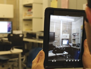
But since AR technology works with GPS coordinates that rely on a device's satellite access to pinpoint a user's location, many AR apps work best outdoors. For facilities managers keen to integrate building information modeling data about a building's systems using their smart device, AR is still a ways off, but maybe not as far as they think.
Researchers at the Georgia Institute of Technology, Atlanta, have built an AR applications platform that promises to help facilities managers pull up BIM data with remarkable precision; the platform also calibrates with their devices' viewfinder. The concept puts "intelligence in the application," says Javier Irizarry, Ph.D., assistant professor in Georgia Tech's school of building construction who is leading the project. "It knows what you need" in an indoor- use scenario, he says, compared to consumer AR apps that rely on the user having to look for locations, such as how far a store is from their car.
Working with Masoud Gheisari, a Ph.D. candidate in Georgia Tech's school of building construction, and Graceline Williams, a research scientist at the school's Digital Building Lab, Irizarry's group first tackled one of the biggest challenges in developing robust AR tools for facilities managers: precise indoor location-tracking features.
Further, the quality of the building information modeling data needed to be tagged with relevant information—such as heating systems throughout the building—and then accessed by the device at the right time. "These information-rich models are overwhelmingly difficult to int-grate into mobile AR solutions," the group wrote in a recent research paper. As a result of their work, they are calling for new guidelines for how BIM models should be parsed and translated into lower geometric and data resolutions, such as indoor situations. This step could help users pull up the right slices of data for different floors.
After studying volumes of existing research devoted to improving indoor location information, the group created a prototype called InfoSPOT, which is short for "information surveyed point for observation and tracking."
Using a special floor mat that helps pinpoint a user's location in a building, the Info-SPOT technology deploys "situational awareness" that helps deliver facilities BIM data that the user can view with a tablet camera.

Post a comment to this article
Report Abusive Comment