Detroit is charting a plan to fight the blight that has plagued it for years, starting with a highly detailed map of the city itself.
Two companies are mapping the 380,217 parcels that comprise the 139-sq-mile city. For each tract, they note the building's condition and whether it is vacant or occupied; they also take a photo, which is sent to an immediately updated database.
The Motor City Mapping Project is a joint effort by Loveland Technologies, a property information software company, and Data Driven Detroit, a non-profit data information and analysis firm, for the Detroit Blight Removal Task Force.
The task force is charged with developing a plan to remove residential, commercial and public building blight and clear blighted but empty lots. The plan is due later this spring.
They have hired local residents as surveyors to gather the information for the Detroit Blight Removal Task Force, which is charged with developing a plan to remove residential, commercial and public building blight and clear blighted but empty lots. The plan is due later this spring.
The mapping project is "total coverage of the city in a snapshot format, looking at something from the street," says Jerry Pappendorf, Loveland chief executive officer.
Armed with iPads, workers inspect and document each parcel's condition—options range from "good" to "suggest demolition." The surveyors also note open and fire-damaged buildings and dumping on occupied and vacant sites.
The mapping project uses "blexting," jargon for "blight texting." A blexting mobile application handles photo surveys of parcels and updates conditions so that anyone checking the post can see immediately if a new building goes up, an existing building is rehabbed, or a derelict building comes down.
"We can't do it without blexting," Paffendorf says. "Having the right technology in place exponentially increases" the survey team's efficiency.
It also allows data monitors to detect crooked or blurry photos as they come in so that the surveyors can reshoot the photo before leaving the site.
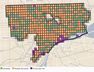
The surveys have been under way for about three months and are almost completed.
The survey information is being combined with 14 different data sets from the city, county, state and federal governments to show information such as ownership and taxation, says Erica Raleigh, director of Data Driven Detroit.
All that data will be used as the task force puts together its proposal for eliminating blight in the city.
The task force, a consortium of city, state and federal agencies, businesses, foundations, professionals and community groups, is led by Dan Gilbert, founder and chairman of Rock Ventures and Quicken Loans; Glenda Price, president of Detroit Public Schools Foundation, and Linda Smith, executive director of the U-SNAP-BAC community agency.


Post a comment to this article
Report Abusive Comment