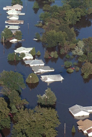
The arrival of Hurricane Floyd in September 1999 could not have come at a worse time for North Carolina. Torrential rains pounded vast areas of the state already saturated by Hurricane Dennis just three weeks before, resulting in massive flooding that exceeded 500-year flood levels in many eastern river basins.
Floyd revealed deficiencies in North Carolina’s flood hazard information resources—hundreds of outdated maps and other guidance premised on decades-old engineering data.
With North Carolina averaging, at the time, the accomplishment of only one FEMA-funded county flood map update study per year, and with 100 counties in the state, officials realized a much more efficient approach was required. They elected to take on the responsibility of modernizing the flood maps under a statewide program.
The new approach was established in collaboration with FEMA’s Cooperating Technical Partner (CTP) program, which allows jurisdictions to take on as many aspects of flood hazard mapping as their resources and expertise allow. Other jurisdictions that have taken the CTP option include the environmental protection departments of New York City and the state of New Jersey.
John Dorman, director of North Carolina’s mapping program, says “We asked for full delegation because we recognized flooding was an ongoing hazard that needed to be addressed, one that would require a continuing program for accurately modeling, mapping, and communicating changes in that hazard and its risks.”
N.C. officials also felt that community-based aspects of floodplain management—from scoping the study areas to handling protests and appeals—would be more successful if handled by state employees, rather than by the federal government. “You get the buy-in of jurisdictions and property owners upfront because they communicate with the same people through the whole process,” Dorman explains.
One of the first challenges, Dorman says, was to overcome a limitation of the old maps, which were based on surveys that used vector data that ended at the county lines. Instead, the state-level program began by conducting new studies of river basins, rather than going county by county.
The eight-year-long process began in 2000 and produced elevation data for more than 30,000 stream miles along North Carolina’s 17 major river basins. Vertical accuracy is two feet, or better, and delivers a 95% level of confidence. Financial contributions from the program’s 16 federal, state, and local stakeholders, in exchange for access to the resulting topographic data, made it affordable for the state to use high-accuracy LIDAR for data acquisition in about half of the study areas.
Now sustained by a state fee on mortgage transfers, the agency is updating vulnerable inland and coastal areas with advanced LIDAR and other technologies. “You don’t scrimp when it comes to getting better data,” Dorman says. “That will help you on the side of mitigation because communities can see true hot spots and figure the actual costs of protection.”


Post a comment to this article
Report Abusive Comment