In their quest to bring swift repairs to a critical floodway and fill a huge scour hole left after the U.S. Army Corps of Engineers breached Mississippi River levees to fight record floods in 2011, engineers have turned to innovative strategies to cope with an environmentally sensitive complication: a blue hole.
The tactics include a closed-loop hydraulic dredge system with booster pumps to jack-up throughput and the use of silt curtains, inspired by wastewater treatment plant designs, to control sediment.
The problem was created when the Corps activated the Birds Point-New Madrid Floodway to reduce flood risk downstream. It meant breaching mile-long "fuse levees" so floodwater could spread across hundreds of thousands of acres of lightly populated farmland.
It worked. The plan prevented billions of dollars in downstream losses. However, a huge scour hole formed at one of three intentional breaches and carved into a local ecological treasure: the blue hole, a deep body of water cut off from the river that clarifies over time.
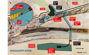
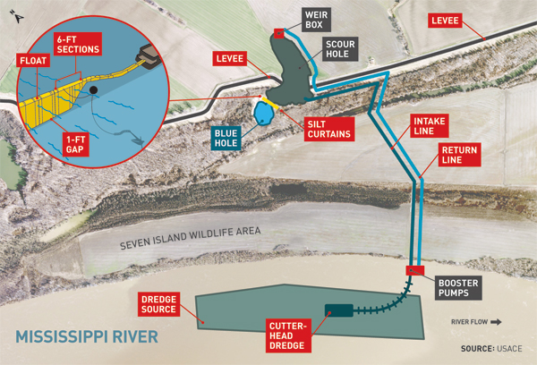
Michael Clay, until recently a civil engineer in the Corps' Memphis District, worked on the project. He says the big scour hole grew at the middle fuse levee because, although explosives were set to blast away only the top five feet of levee and create a mile-long, broad-crested weir, a low spot developed and focused the flow. It took out 800 linear ft of levee and displaced 400,000 cu yd of earth, leaving an 11.5-acre, 50-ft-deep scour hole.
The job of reversing the damage while protecting the blue hole was tasked to the Corps' Memphis District.
By the end of May, the Corps had success in sight. Labor crews capped the filled and consolidated scour hole with clay to set the stage for restoration of the blown levee itself, says Dennis Abernathy, the Corps' project manager. By mid-June, one of three prequalified contractors bidding for task orders should be at work on a $45-million restoration of the levee that once crossed the site, he says.
"We are expecting the contractor to be on the ground in early June and have the levee back to pre-flood height of 62.5 ft in time for winter," Abernathy says.
It’s Happened Before
Operation of the floodway, which the Corps engineered after the horrific floods of 1927, occurred once before in 1937. At that time, Clay says, the middle fuse plug left a two-acre scour hole about 20 ft deep. "When the levee was reconstructed, the alignment bypassed the scour hole," he says. The unfilled hole became the blue hole. "It is considered a vital fish and wildlife resource by the Missouri Dept. of Conservation and Missouri Dept. of Natural Resources," says Clay, now a hydraulic engineer with the Corps' Walla Walla District.
The new scour hole cut into the edge of the blue hole, creating a combined 13.5-acre body of water. "Before the levee could be reconstructed, we had to fill in the new scour to natural ground elevation without filling in or harming the historic hole," Clay says.
Truck-hauling sand fill was impractical because of the volume, distance from the pits and impact on roads, Abernathy says. "We would have been looking at three months to fill that hole."
Engineers used excavators to reclaim as much washed-out material as they could from adjacent fields, and they added dredged and hydraulically pumped sand from the Mississippi, says Jim Pogue, a spokesman for the Memphis District.
Great Lakes Dredge & Docks (GLLD), Oakbrook, Ill., began work on Oct. 6 on a $2.9-million contract to pump fill. A 24-in. cutter-head dredge pumped 15,000 to 20,000 cu yd per day. "The Corps did some real quick footwork to put our dredge on-site and begin pumping in a matter of days," says Jon Nieman, vice president of GLDD's rivers and lakes division.
But shielding the blue hole from the dredge spoil was another matter. The first idea was to build a rock containment dike to separate the new hole from the old one. But with the 50-ft depth, estimates were that a rock dike would cost $2.5 million to $3 million and might not even do the job.
Then Clay, drawing on a pre-Corps stint in wastewater treatment plant design, suggested a silt curtain: a barricade of thick tarps with floats on the top and weights on the bottom to control sediment migration. Some wastewater treatment plants use them as baffles to partition lagoons and isolate sediment.
Clay says he expected the idea to get shot down, but "Cory Williams, our geotechnical branch chief, and Shane Callahan, civil design section chief, said to look into it."
Clay knew the curtains would have to be custom-made to fit the deep bowl of the hole. He didn't know if he could get them made and installed quickly enough, but he ran with it. He made a survey, prepared construction drawings and searched for manufacturers online. Ultimately, he commissioned fabrication of the curtains for $50,000. "Me and three other guys put it in," Clay says. The system was in place by Sept. 26.
Elliott Davis, speaking for the curtain supplier, Granite Environmental Inc., Sebastian, Fla., says silt curtains manage suspended solids by speeding settlement and dropping solids in defined areas. He says the curtains often are used incorrectly, "but, in this particular situation, it was the perfect solution."
The curtain panels are in 6-ft widths of varying lengths to match the hole's bottom contour. Lengths are adjusted by reefer lines so the lower edge hovers one foot above the bottom to allow for some water flow.
The panels arrived on an 18-wheeler. "We rolled the curtain off, borrowed a farmer's tractor and brought it to the landing," Clay says. "We did final assembly—zip-tying adjacent panels—pulled it out in the water with a boat, attached the anchors, loosened the reefer lines and unfurled the panels. They work just like mini-blinds."
With Frank "Tater" Mills, a Corps design engineer, and two men from Granite, Clay installed two parallel rows of curtain with a 20- to 40-ft gap between. The first curtain acts as a baffle, slowing currents and dropping sediment. "[Sediment] barely goes under the primary curtain and only has a vertical foot before it impacts the second curtain, which also has a one-foot gap at the bottom," Clay says. "We calculated an angle of repose and figured out how steep of a slope was required—if you just dump sand out there—to hold its own slope."
Clay says if the only objective were to control sediment transfer and the cost were the same as a rock dike, he still would prefer the curtain over a dike "because it was more effective."


Post a comment to this article
Report Abusive Comment