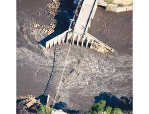
Officials in northeastern Iowa are cleaning up in the aftermath of a July 24 dam failure, and early analysis indicates an earthen berm next to a section with concrete spillways was overtopped and eroded away when the rain-swollen, 9-mile-long Lake Delhi overwhelmed it.
“It appears at this point that there was just a lot more water than the dam was designed for,” says Lori McDaniel, supervisor of floodplain management and dam safety programs for the Iowa Dept. of Natural Resources. Further, she says the concrete spillway next to the berm appears to be structurally sound.
The dam passed its last routine inspection in May 2009. “At that time, we didn’t find any issues or anything that would cause a failure,” says McDaniel.
The 150-ft-long breach formed when 10 inches of rain swelled the 448-acre lake to 9,920 acre-ft, or 3.2 billion gallons, from its normal 3,790 acre-ft, or 1.2 billion gallons of water.
A U.S. Geological Survey chart shows that Lake Delhi’s flood level is 15 ft, and that the level on July 24 reached nearly 25 ft.
The lake was formed by an 88-year-old concrete dam built to harness hydroelectric power from the Maquoketa River. The 48-ft-tall concrete dam section is 25 ft wide at the top and 200 ft wide at the base; a county road runs across it. The generators have long been removed, and the three spillways only are used to control the water level in the lake.
Since 1973, the dam has been owned and maintained by the Lake Delhi Recreation Association, a group of homeowners among the 900 residences that line the banks of the lake.
Fortunately, the torrent that resulted from the breach swept downstream though miles of farmland before bringing floods to the towns of Hopkinton and Monticello, seven and 16 miles downstream, respectively. Residents were warned and had time to flee. No injuries were reported, but 100 homes and 20 businesses were damaged in Monticello.
One major casualty is Monticello’s sewage treatment plant, which was flooded with six feet of water and still was not working several days after the waters receded.
Public Works Director Dana Edwards estimates it will cost up to $1.2 million to clean up the building and replace two pumps, the boiler, a UV system and control panels.
Edwards says this is the third time the plant, which sits by the river, has flooded in eight years. “We’re in the process of building a dike to protect the plant,” he says, “but it’s not done yet.”
The city asked residents to minimize use of water. It is pumping untreated wastewater directly into the river. The city’s clean water comes from three wells that are located high out of flood range, says Edwards.
Officials credit the safe evacuation to the fact that experts saw the problem developing and had modeled just such a disaster for emergency planning.
Brenda Leonard, emergency management coordinator for Jones County, Iowa, where Monticello is located, says the Lake Delhi Recreation Association alerted her when water flowing through the dam increased, and then, after being warned at 12:50 p.m. that the berm had breached, she checked computer models the National Weather Service had prepared in advance of such a event.
The reports showed how high the water was predicted to rise and how long—about five and a half hours—the flood would take to reach Monticello, a town of 3,600 people.
As the flood approached, the Monticello police chief and a town councilman took the National Weather Service report and a GPS unit and marked the expected extent of the floodwaters on locations around town. “The timing and extent of the flooding predicted in the NWS report was amazingly accurate,” says Leonard.
“We didn’t see a huge wave rush into Monticello,” she says. “The river just kept rising slowly for several hours.”

Post a comment to this article
Report Abusive Comment