Heavy rains continued pelting Colorado through the weekend, slowing the state's efforts to fortify regions hit by “biblical floods” that struck the state early last week.
By some counts, officials said, about 700 residents who live near the foothills where the flooding hit, and across the Denver metro area, were still unaccounted for after flooding washed out major roads and highways after last week's heavy rain. Rescue efforts through the weekend had reached hundreds if not thousands.
At least three people were killed and thousands were stranded since the floods hit the state, prompting evacuations.
The Federal Emergency Management Agency and the state's division of Homeland Security said 12 more counties were added to the emergency disaster declaration, which initially included Boulder, El Paso and Larimer counties since last Tuesday, Sept. 13, when the states of emergency went into effect.
Some communities, including Boulder and those along the I-25 corridor north to Fort Collins, have received 12-15 in. of rain since the storm intensified on Tuesday night—nearly half of the average annual precipitation for the region. That is the equivalent of snowmelt from 9.5 ft of snow.
Colorado's National Guard was helping stranded residents and motorists following orders by Gov. John Hickenlooper, whose helicopter was pressed into service to help with evacuations during a flyover to survey damage. The Obama administration has authorized federal disaster funds to help with recovery and cleanup.
Officials say it is too early to offer damage assessments because they still can’t get into many of the hardest-hit areas. The town of Lyons, north of Boulder, is cut off on all sides by rising waters and flooded highways.
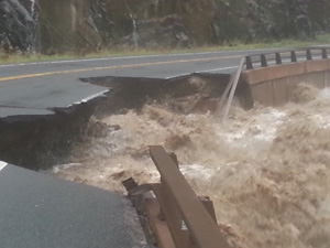
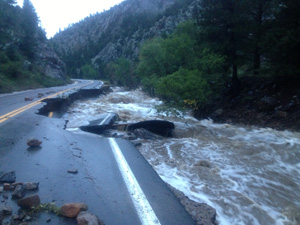
“We do not have any [damage] estimates right now and probably won’t for a few days,” says Mindy Crane, deputy director of communications for the Colorado Dept. of Transportation. “There are many areas we haven’t been able to fully assess the damage or even access.” Crane says that the agency is focusing nearly all its efforts on removing debris and reopening roads. Several highways leading into the foothills have been washed out and will be closed “indefinitely,” including Highway 72 through Coal Creek Canyon and Highway 119 west of Boulder.
Thousands of residents have been evacuated from their homes in Boulder, Estes Park, Commerce City, Longmont and other cities situated near the region’s swollen rivers and streams. Many area schools and businesses were closed on Thursday and Friday and officials asked drivers to stay off the roads.
As of early Friday afternoon, the Colorado Dept. of Transportation had closed portions of more than 35 major highways, including Interstate 25 north from Fort Collins into Wyoming and I-70 west of Denver due to mudslides. Cities and counties have closed hundreds of roads, bridges and side streets due to flooding.
Tony Milo, executive director of the Colorado Contractors Association, the state’s heavy-highway arm of the Associated General Contractors of America, says, “It's all very early but we are hearing $50 million-$100 million just in CDOT repairs that will be needed, and there will be more at the local level.”
Floods worsened along Boulder Creek and the Big Thompson River on Thursday night. The National Weather Service warned residents late Thursday that “a wall of water” was headed toward Boulder. The University of Colorado Boulder campus cancelled classes on Thursday and Friday and there were unconfirmed reports that 30% to 40% of CU campus buildings may have been damaged by the storm.
Boulder County officials report that water flow in Boulder Creek reached more than 4,500 cfs, double its peak flows over the past 25 years. All rivers and creeks in the area are reported to be at or above historic flood levels.


Post a comment to this article
Report Abusive Comment