Groundwork for reducing future storm-surge damage in New York City began years ago. Academics and engineers have long offered scientific assessments of the risks and proposed a variety of solutions using both hard and soft infrastructure. While questions remain, many experts agree on two things: Severe flooding risk will continue to increase and dedicated, multidisciplinary professionals must work together with the public to plan a response to those risks.
As the Sandy cleanup continues, Gov. Andrew Cuomo has touted the idea of sea-barrier protection around New York City. Long before Sandy, a group led by Douglas Hill, a professor at the State University of New York Stony Brook, pushed for construction of a specific set of surge barriers, with some engineering firms offering conceptual designs pro bono.
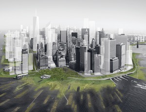
Other engineers and planners, noting the significant time and cost required to build a seawall, have pushed for soft infrastructure solutions. A prescient exhibit called "Rising Currents" at the Museum of Modern Art last year featured teams' renderings of ways to protect the city against flooding. One proposal developed by Adam Yarinsky and Stephen Cassell of Architecture Research Office, with Susannah Drake of dlandstudio, presented solutions for lower Manhattan, one of the harder-hit areas of the city.
"We used both hard and soft strategies to create a new landscape for lower Manhattan, with some of the engineering from a landscape approach," says Drake, a landscape architect and professor at the Cooper Union and senior associate of the Cooper Union Institute for Sustainable Design. Her team proposed a redesign of streets using porous pavements that can absorb surface runoff. Drake notes that while state regulations call for managing stormwater runoff up to a 1.2-in. precipitation level, "we've had nine storms out of a hundred that have exceeded that." The team suggested putting all underground utilities in waterproof vaults with access hatches and adding sequestration areas to capture and contain saltwater.
For the perimeter areas, "we proposed adding upland parks and freshwater wetlands, then saltwater wetlands farther out to sea" to provide buffers and break up the frequency of the waves, says Drake.Dredged material from harbor-deepening projects, combined with geotextile layers, could form artificial islands arranged in a pattern to maximize the buffer zone. On the Lower East Side, a line of earthwork mounds strengthened by concrete would act like levees.
Advanced Risk Analysis
Beyond local efforts, guidance for devising policies and designs to reduce exposure in the city and the region already is available, thanks to advanced risk analysis methodologies, storm modeling, engineering and project execution that helped rebuild New Orleans'defenses after Hurricane Katrina in 2005.
Having conceptual designs does not mean we are ready to start building defenses, caution some experts, including Lewis E. "Ed" Link, a senior research engineer from the University of Maryland. He led the task force that analyzed the performance of the flood protections in New Orleans during Katrina (ENR 4/2/07 p. 32). Link helped develop advanced risk assessment methodologies for designing large, distributed systems to reduce risk from major weather events.
The engineer says barriers are "an obvious option," adding that the city's high exposure "would justify damn near anything, but [first] you need to have a pretty comprehensive feel for the hazard."
Link suggests that designing to protect against extreme-weather events that have occurred is not enough; a system's entire spectrum of potential risk needs to be assessed at all locations before the required protection levels can be understood. "It could take a couple of years to define the hazard and describe and categorize the systems that are there and the systems that you might want to try and build," he says.
Klaus Jacob, a research scientist at Columbia University's Earth Institute and an author of related studies, had predicted the potential damage from Sandy last year after Hurrican Irene. "Serious engineering studies have not been done yet," he says. "We made an assessment, but that doesn't mean engineers were authorized to spend time and money to fix the problem even just at the current level—and additional sea-level issues are coming."
Just for city transport systems, a single standard is needed, Jacob says. "The transit systems in New York are interconnected, so if they have different standards, it will feed the flooding from one system to another," he says. Coordination among numerous agencies is "a huge task not just engineering-wise, but administratively. A panel has to be put together that makes recommendations. Then comes the hard part: legislatures and federal officials have to set the monies aside," he adds.
Link says, "You have to do what we did in New Orleans. You have to scientifically create a spectrum of storms that are logical for the Northeast and statistically model how often you might experience them." He points out that simply ascribing levels of risk based on a storm's category ranking on the Saffir Simpson scale does not begin to describe the impact of Sandy, whose power was amplified by two other major weather influences.
"It's complex. Everybody is now going to want to do this in nine months … but we should have been doing it 20 years ago," Link says. He observes, "New York has an opportunity for sanctuary-in-place. Some utilities need to be a lot more robust and flood-proof, starting with not having them in the basements."
Barrier Barriers
The advantage of a barrier system would be that, if built, "it can provide breathing space to implement major resilient strategies in the city behind it," says Graeme Forsyth, CH2M Hill chief engineer for gates. "It can also be designed to account for the increases in water level and storminess predicted by the scientific community and so [assure] medium-term protection, say, until 2100." Preliminary studies are needed to identify sedimentation and scour issues, sources of construction materials, forecast of water levels, environmental and societal impacts, and possible changes to current codes, he adds.
Nickolas K. Coch, a coastal geologist and professor at Queens College of the City University of New York, wrote in a response to Hill's article describing his barrier plan in the Journal of Coastal Geology earlier this year. Coch noted, "Any discussion about surge barriers in New York Harbor must consider the oceanographic conditions and not just the water levels there."
"There have been no studies about how these barriers would affect marine traffic, the flow segregation at the southern part of the Lower Bay, and the dissolved oxygen levels in the harbor," Coch says. For now, more realistic goals would include adoption of city zoning provisions mandating flood protection in vulnerable areas and extensive emergency management planning.
Sea-barrier systems such as those in London and Venice are "perfectly feasible," albeit costly, says Matthys Levy, chairman emeritus of Weidlinger Associates and author of a book on climate change. "There's a number of other problems that will need longer-term solutions," including building residences and powerplants along the waterfront. He suggests scientists and engineers should form a team to advise policymakers.
Indeed, Drake says, "We tried in vain to get a feasibility study with the city planning department to figure out further engineering needs and cost" after the "Rising Currents" exhibition. Like Jacob and Levy, she also calls for a dedicated team of experts, one that includes engineers, architects and landscape architects. James Quinn, Weidlinger principal, adds that a geotechnical engineer and an ecologist could round out such a team. "We can't do it without each other," he says.


Post a comment to this article
Report Abusive Comment