


The California Geological Survey's recently released map of active splays around the 10-mile Hollywood fault in Los Angeles shows two projects—one proposed and one under construction—in violation of state law because they are sited atop splays of an active fault. The Hollywood fault has the potential for a magnitude-7 temblor.
The geological survey hurried work on the Hollywood fault map, released on Jan. 8, in response to a controversy that erupted last year about building on active faults . The planned $664-million Millennium Hollywood and the under-way BLVD 6200 projects were both approved by the City Council. Environmental impact reports and city reviews for each project were based on outdated maps, according to the geological survey.
An outdated map, however, is no excuse for building on top of an active splay, says John Parrish, the California state geologist. The developers, Millennium Partners and Clarett West Development, should have independently identified whether their buildings were above active splays, he adds.
"It's a tough issue because they've spent a lot of money already, but there were plenty of indications that they were in a zone of required investigation and the city should have required a more thorough on-site investigation," Parrish says. "We feel pretty confident that BLVD 6200 is right on top of an active splay."
State mapping work is slow. The Alquist-Priolo Earthquake Zoning Act, enacted after 1974's Sylmar quake to map main faults and connected splays and traces, was never funded. "We had to use allotments from our general fund, but that has been cut dramatically," Parrish says.
Main-fault mapping is done, but the number and location of splays and traces remain unknown. The geological survey has mapped 5,000 miles of active traces and has about 2,000 miles and 300 maps to go. Some of these are for densely populated areas, including San Francisco and San Diego. Things could speed up as Gov. Jerry Brown (D) has proposed an increase to the mapping budget of about $1.3 million each year, says Parrish.
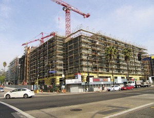
Work is ongoing at BLVD 6200. In the past, some owners have stopped construction when the release of a new map indicated a building was above an active fault trace, says Parrish. The Los Angeles Unified School District even removed some existing schools. "We don't feel like BLVD 6200 performed a study designed at identifying an active trace of the fault beneath the site," he adds.
Robert Silverstein, counsel for the Hollywood community group Stop the Millennium Project, filed a case against Millennium Partners in August, accusing it of similar neglect.
Silverstein also alleges a considerable amount of wrongdoing among city officials involved in the project's approval. "There is a culture of secrecy and rule-breaking at the Los Angeles City Hall," he says. "The Millennium project is an obscene example of the City Council elevating the interests of developers over the interests of the citizens that the council supposedly represents—to the point, this time, of actually imperiling thousands of lives."
Millennium Partners and its consultant, Langan Engineering, say their geotechnical investigations for the two-tower development did not reveal active traces.
BLVD 6200 is not currently facing legal action but is in danger of being found in violation of state law. Morley Builders, the prime contractor, would not comment on specifics about the survey, but Justin Grant, a Morley spokesman, says he believes the project is adjacent to—not atop—a fault trace.


Post a comment to this article
Report Abusive Comment