
Teams of engineers on New York City's Staten Island had done, by Nov. 6, rapid structural assessments of more than 5,000 houses in areas affected by Hurricane Sandy. They have a total of 19,000 houses on the list and are assessing more than 1,000 each day.
Though New Jersey's Office of Emergency Management says assessments are under way in the hardest-hit areas of the state, there are no details available. At press time, neither state had a tally of how many damaged houses were safe to enter.
"This raises a big argument of what do we design to," says Malcolm G. McLaren, president and CEO, McLaren Engineering Group, West Nyack, N.Y. McLaren surveyed the devastation at the Jersey shore while checking out his own house there, which had 5 in. of water.
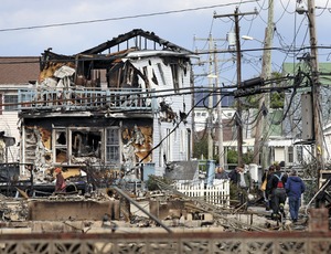
The greatest damage on Staten Island is at the southeastern end. The flooded houses in the worst shape are those hit by the Atlantic Ocean's storm surge plus a violent wave on top, says one engineer. In some places, "we can look at entire blocks at once and say, 'This looks good,' " he adds, declining to be named.
The engineer requested anonymity because his client, the New York City Dept. of Buildings, has not authorized any of the hired private firms to speak to the press. The DOB did not respond to requests for comment.
Since Nov. 1, 10 teams of two, including a DOB inspector and a structural engineer, have been canvassing the hardest-hit areas in the New York City borough of Queens. They are completing 300 to 600 evaluations per day. Often, the tempo is slowed by the need to climb over debris, says one engineer, who also requested anonymity.
The storm surge, up to eight feet, had mostly drained from the Queens houses by Nov. 6. In Far Rockaway, where many houses have basements, water did not always reach the first floor. In Breezy Point, most houses were built on stilts four feet above the ground; in those cases, the first floor took on about four feet of water.
The teams are using the Applied Technology Council's ATC-45 form for rapid assessment of structural damage after wind storms and floods. Engineers look for collapse, partial collapse or buildings off foundations. They check whether houses are dangerously out of plumb. They look for damage to primary structural members and the racking of walls. They observe whether there are falling hazards due to non-structural damage. They look for geotechnical hazards, including scour, erosion and slope failure. And they look for submerged electrical lines and fixtures and leaning trees.
After scoring a house, a team posts a placard: Red means "unsafe—do not enter or occupy." Yellow means "restricted use," with certain areas off-limits. Green signifies "lawful occupancy is permitted."
"Green means they can go in, but there are still electrical, plumbing, drywall and other problems," says one engineer.


Post a comment to this article
Report Abusive Comment